Portage Distances (when travelling West to East)
99% of paddlers following the Canoe Trail are content to start at the top of Neptune's Staircase at Banavie and finish at the top of Muirtown Lock Flight in Inverness. This avoids long portages crossing major roads and rail lines at both ends of the canal.
However, for those paddlers who wish to have their pictures taken beside the start and finish Great Glen Way monoliths at Corpach and Clachnaharry Sea Locks, it is a very easy walk from Banavie or Muirtown.
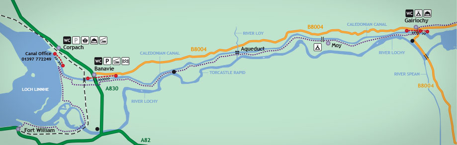
(When passing through Gairlochy outside lock keeper hours (0900-1700 April to September), the lower lock gates are closed overnight and a longer portage route is required from Gairlochy Lower).
| West District | |||
| Loch Linnhe (Corpach) | to | Corpach Upper | 500m |
| Banavie Lower | to | Banavie Upper | 650m |
| Gairlochy Middle | to | Gairlochy Upper | 350m |
| Gairlochy Lower | to | Gairlochy Upper | 650m |
| Middle District | |||
| Laggan Bay | to | Laggan Upper | 250m |
| Cullochy Upper | to | Cullochy Lower | 200m |
| Kytra Upper | to | Kytra Lower | 200m |
| Fort Augustus Upper | to | Oich Pier | 750m |
| East District | |||
| Dochgarroch Upper | to | Dochgarroch Lower | 175m |
| Tomnachurich Upper | to | Tomnahurich Lower | 250m |
| Muirtown Upper | to | Caley Inn Car Park | 350m |
| Muirtown | to | Seaport Marina | 600m |
| Clachnaharry Works | to | Beauly Firth (Clachnaharry) |
350m |